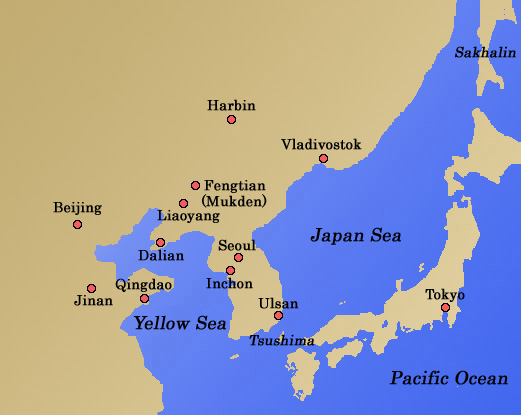
1. East Asia
Vladivostok
@@´Map
|
@Port city in the Maritime Province of Siberia, southeastern end of Russia. Vladivostok is a natural harbor and has been a prosperous city as a center of Russian far east province since the port was opened in 1860. It was the navy base of Russian Navy Vladivostok Squadron during the Russo-Japanese War and had very important military value.
|
Sakhalin
@@´Map
|
@A large island north of Hokkaido, Japan, lying from south to north. This island is called "Karafuto" in Japan, and "Sakhalin" in Russia. At the end of the Russo-Japanese War, the Japanese forces launched landing operations at the south end of the island and succeeded in occupying and controlling the island. After the war, the southern portion of the island from the 50th parallel of the north latitude was ceded to Japan.
|
Harbin (Haferbin)
@@´Map
|
@It is the capital city of current Heilongjiang Province of China. It used to be a fishing village and Russia made it a base for constructing the Chinese Eastern Railway in 1898. The construction of railway from Manchuli to Vladivostok via Harbin (mainline of the Chinese Eastern Railway) and from Harbin to Dalian and Lushun (branch line of the Chinese Eastern Railway) highlighted the city, and Russian-style town was constructed in Harbin.
|
Tsushima
@@´Map
|
@An island in Nagasaki prefecture of Japan. Tsushima Strait is named after the island. In the Russo-Japanese War, the Japanese Fleet and the Russian Fleet fought the naval battle off this island (Battle of Tsushima).
|
ˆ Return to the top of the page. ˆ
|
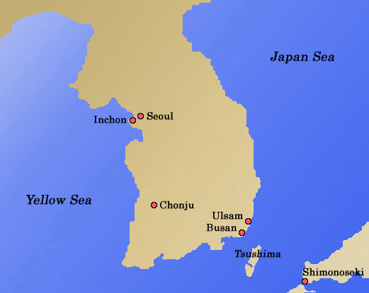
2. Korean Peninsula
Inchon
@@´Map
|
@Port city in Gyeogi-do of Korea. The port was opened by the "Japan-Korea Friendship Treaty (Kanghwa treaty) of 1883" and a foreign settlement was placed and the town was developed. In the Russo-Japanese War, the Japanese Fleet and the Russian Fleet fought the naval battle off this city (Battle off Inchon).
|
Ulsan
@@´Map
|
@It is a city in Gyeongsang nam Do of Korea, facing the Japan Sea. In the Russo-Japanese War, the Japanese Fleet and the Russian Fleet fought the naval battle off this city (Battle off Ulsan).
|
Seoul
@@´Map
|
@ It is the capital city of Korea. "Seoul" means "the capital city" in the Korean language, and used to be written in Kanji as "Hansong" in the days of Korean Dynasty. After the annexation of Korea by Japan, Seoulfs new name as "Keijo" was adopted.
|
Chonju
@@´Map
|
@It is the capital city of Jeollabuk-do Province of Korea. The city was occupied by the peasants' force in the "Tonghak Peasants' War of 1894".
|
ˆ Return to the top of the page.ˆ
|
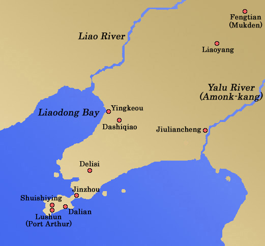
3. Liaodong Peninsula
Yalu River, Amonk-kang
@@´Map
|
@It is a large river at the border of the Peoplefs Republic of China and the Democratic Peoplefs Republic of Korea. Here, the first land battle of the Russo-Japanese War was fought (Battle of Yalu River).
|
Jinzhou
@@´Map
|
@Town in Liaoning Province of China. The town is on the railway of the Harbin-Dalian Line (between Harbin and Dalian, branch line of former Chinese Eastern Railway) leading to Lushun. The battles of Japanese and Russian armies were fought here and at the suburban Nanshan.
|
Jiuliancheng
@@´Map
|
@Town in Liaoning Province of China, a town on the Yalu River. Here, the first land battle of the Russo-Japanese War was fought (Battle of Yalu River).
|
Shuishiying
@@´Map
|
@Place north of Lushun in Liaoning Province of China. It is known as the place where General Nogi of the Japanese Army and Lieutenant General Stessel had a meeting in the Russo-Japanese War.
|
Dashiqiao
@@´Map
|
@Town in Liaoning Province of China, a town on the Harbin-Dalian Line (between Harbin and Dalian, branch line of former Chinese Eastern Railway). Here, a battle of the Russo-Japanese War was occurred around this town (Battle of Dashiqiao).
|
Dalian
@@´Map
|
@Port city at the southern end of Liaodong Peninsula, Liaoning Province of China. Dalian is the terminal of the Harbin-Dalian Line (between Harbin and Dalian, branch line of former Chinese Eastern Railway) and was ceded to Russia demanding a non-freezing port in 1898 and the construction of commercial port was started. Hard battles were fought over Lushun and Dalian during the Russo-Japanese War. After the war, Japan ruled Dalian, where the head office of South Manchurian Railway Co., Ltd. (Mantetsu) was established.
|
Delisi
@@´Map
|
@Town in Liaoning Province of China, a town on the Harbin-Dalian Line (between Harbin and Dalian, branch line of former Chinese Eastern Railway). Here, the battle of the Russo-Japanese War was fought around this town (Battle of Delisi).
|
Fengtian, Mukden
@@´Map
|
@Shenyang, capital city of Liaoning Province of China, the largest city in northeastern part of China. It used to be called Mukden as the capital of Qing and later renamed as Fengtian after the capital moved to Beijing. Here, the largest-scale land battle of the Russo-Japanese War was fought (Battle of Fengtian).
|
Liaodong Peninsula
@@´Map
|
@Peninsula in the southern part of Liaoning Province of China. Liaodong Peninsula is south of the line connecting the mouth of Liao River and the mouth of Yalu River, and Huanghai (Yellow Sea) is in the east and Liaodong Bay is in the west. The peninsula was ceded to Japan after Sino-Japanese War of 1894, but was leased to Russia after its return to Qing as a result of the Triple Intervention. After the Russo-Japanese War, Japan ruled the region and named it as Kwantung Province.
|
Liaoyang
@@´Map
|
@Liaoyang is a city on the Harbin-Dalian Line (between Harbin and Dalian, branch line of former Chinese Eastern Railway) in Liaoning Province of China. Shoushan in the cityfs neighborhood was a place of the bloody battle of the Russo-Japanese War (Battle of Liaoyang).
|
Lushun, Port Arthur
@@´Map
|
@It is a deep water port west of Dalian, southern end of Liaodong Peninsula, Liaoning Province of China. Russia leased the city as a result of the Triple Intervention after the Sino-Japanese War and constructed strong fortifications there, and it became the site of the furious battle of the Russo-Japanese War (Siege of Fortress Port Arthur).
|
ˆReturn to the top of the page. ˆ
|
4. Shandong Peninsula
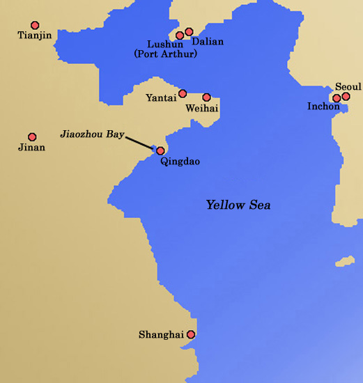
Weihai
@@´Map
|
@Weihai, former name is Weihaiwei (Ikaiei). Weihai is a port city facing Bo Hai (Bokkai) north of Shandong Province of China. Japan attacked this region in the Sino-Japanese War and occupied it for three years. Britain leased Weihai in 1898 in opposition to Russia that leased Lushun and Dalian, but Britain returned it to China in 1930.
|
Jiaozhou Bay
@@´Map
|
@Jiaozhou Bay is a sea area facing Huanghai (Yellow Sea) south of Shandong Peninsula of China. In 1897 Germany leased this area from Qing and constructed a modern city in Qingdao as their Far Eastern base. Subsequently, this area was occupied and stationed by Japanese forces that joined the First World War and was returned to China in 1922.
|
Qingdao
@@´Map
|
@Qingdao is a city of the east shore of Jiaozhou Bay, facing Huanghai (Yellow Sea) south of Shandong Province of China. It used to be a fishing village, but was developed as a trade and military port together with the lease by Germany and the construction of the railway connecting with Jinan, capital of the province.
|
ˆReturn to the top of the page.ˆ
|
5. U. S. East Coast
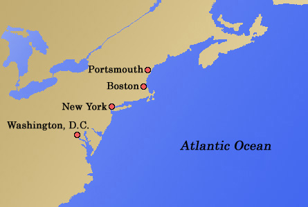
Portsmouth
@@´Map
|
@Portsmouth is a port city in New Hampshire State in the east coast of the United States of America. The Japanese and Russian delegates gathered here for the peace conference of the Russo-Japanese War in 1905 at the mediation of U.S. President Roosevelt.
|
ˆReturn to the top of the page. ˆ
|
|